- 首页 >> Research >> Research Progress
Research Progress
Visible-shortwave Infrared Advanced Hyperspectral Imager for the GF-5 Satellite is Delivered
The GF-5 satellite was launched at the Taiyuan launch site on May 9, 2018, equipped with the visible-shortwave infrared advanced hyperspectral imager (AHSI) developed by Shanghai Institute of Technical Physics, which is the first large-width, wide-spectrum and highly quantitative satellite-carried hyperspectral imager all around the world. On May 28, 2018, AHSI completed on-track heating decontamination, and then started up and running. After half a year of on-orbit testing, on December 28, 2018, AHSI passed the “Inspection Summary for the Visible-shortwave Infrared Advanced Hyperspectral Imager On-orbit Test " organized by the user and satellite overall, and then was transferred to application test phase. On February 22, 2019, AHSI cooperated with the user to complete all on-orbit test projects, and passed the "Inspection Summary for the GF-5 satellite engineering on-orbit test", and then was delivered to users, formally into business operation.
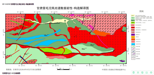
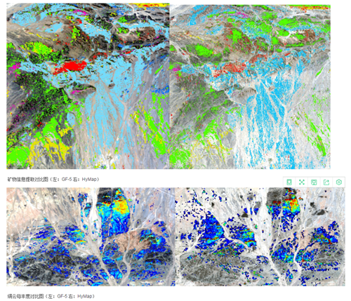
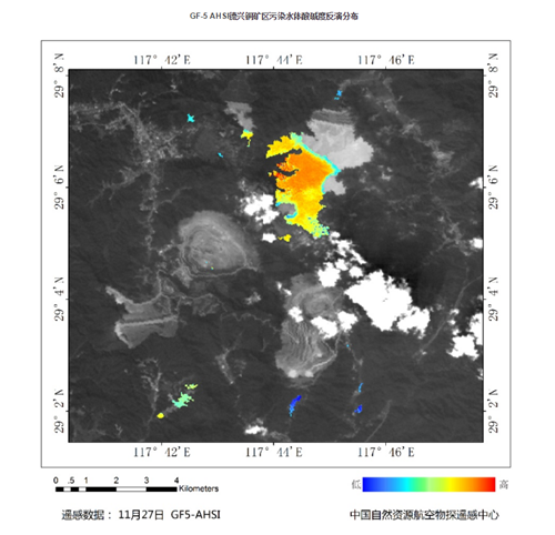
The application test of the visible-shortwave infrared advanced hyperspectral imager on-orbit test was highly evaluated in the on-orbit application test summary report led by the main users such as the Satellite Environment Application Center of the Ministry of Ecology and Environment and the Aviation Geophysical and Remote Sensing Center of the Ministry of Natural Resources. First of all, the water environment monitoring capability is outstanding. The space structure and the spectral presentation ability of the AHSI load are excellent, the expression of small river channels is very clear, the detail transition is smooth, and the water quality parameter inversion results are spatially heterogeneous. Compared with the similar mainstream load products at home and abroad in the same period, the water quality inversion results “chlorophyll a, nutritional status distribution” is consistent with Landsat8/OLI and Sentinel-3/OLCI, and the AHSI load makes the inversion extraction levels of water quality more abundant due to high spectral resolution and sensitivity. “Transparency, total suspended solids Concentration and blooms” are superior to similar loads. Secondly, the fine classification ability of the features is outstanding. In terms of classification and extraction of coverage information of the features,such as soil, buildings, vegetation, water bodies, etc., AHSI hyperspectral distinguishable features are several times more than that of multispectral. Since different subclasses of similar features have more differential spectral response information in short-wave infrared, AHSI distinguishable types and accuracy of the features have been further improved. The classification accuracy of multi-view test images exceeds 95%, and the kappa coefficient exceeds 0.9, which are significantly better than Landsat8/OLI, EO-1/Hyperion and GF-1/16m cameras. Thirdly, the lithology-structural interpretation ability is outstanding, and the interpretation results are consistent with the existing geological data. Fourth, the mine's mineral information extraction capacity is outstanding. The mineral characteristic spectrum is clearly identifiable, and the characteristic spectral absorption position is accurate. The mineral information extraction result, the identified mineral species, and the relative abundance distribution of the mineral are basically consistent with the re-sampling HyMap application results. Fifth, the mine geological environment monitoring capability is outstanding. The results of water extraction in the mining area are clear and easy to distinguish, and the spectral characteristics are obviously different. The monitoring results of the vegetation growth in the mining area using the same area image inversion are consistent with the inversion results of Landsat 8 in the same period. The conclusions of the GF-5 satellite on-orbit test point out: in terms of the monitoring of water bloom and water quality in inland water such as rivers, reservoirs, lakes and etc., the fine extraction and abundance quantitative geological survey of mine mineral information, and the fine classification and monitoring of vegetation ecology and mine environment, the AHSI load presents outstanding on-orbit application capability, reaching the highest level of satellite-carried hyperspectral remote sensing at home and abroad.

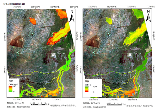
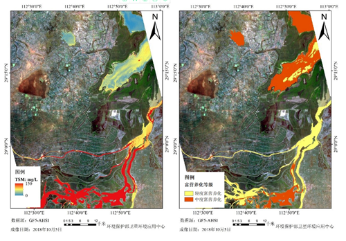
Water quality inversion map of the Dongting Lake;
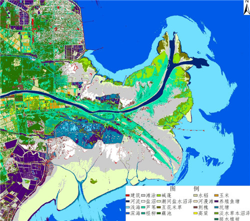
Fine classification map of the features at the Yellow River estuary;
|
|
|
Lithology-structural interpretation map of Ying Mao Tuo, Gansu; |
|
|
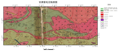


1:200,000 geological map of Ying Mao Tuo, Gansu.