Engineering Department III lies its researches upon the areas of geostationary satellite based imaging and detection, special surveillance cameras, solar sensors. It focuses its researches on the key technologies including scanning mirrors and gimbal pointing, large aperture and large field of view optics, precision engineering and structuring, high speed signal processing. It is also exploring the new ways of thermal control of precision instruments and quantity analysis techniques of remote sensing instruments.
Research Groups
ptics
lectronics
ngineering and Structures
round Segment and Calibration
Phased Projects
Engineering Department III conducts its researches primarily on the development of the payloads of geostationary satellites. It is in charge of several important phased projects of national interests.
FY-2 Scanning Radiometers
The FY-2 Multi-Channel Scanning Radiometer (MCSR, Figure) is the self-developed core payload onboard the geostationary meteorological satellites FY-2. Large aperture, high resolution, high precision and high reliability are the main characters of this payload. It went into phase in 1983 and was successfully launched the first time in 1997 as a 3-channel scanning radiometer. It was successfully launched again on June 25, 2005 and went into work on January 1, 2001. The improved 5-channel scanning radiometer went into critical technique research phase in 1999 and was successfully launched in 2004. It is still in service to date and is providing large quantity data every day for the weather forecasting. MCSR is an important contribution of SITP for the course of this country抯 geostationary meteorological satellites.?
FY-4 Scanning Radiometer
The imaging radiometer on the 3-axis stable geostationary satellite (Figure) FY-4 is a project supported by the Defense Science and Technology Bureau and Aerospace Science and Technology Co. It works at 12 wavebands and is one of the two core instruments on the FY-4 meteorology satellite. FY-4 multi-channel imaging radiometer was established as a key technology demonstration project in 2002. It finished its high level design in 2003, and finished its industrial model in 2006 with the breakthrough of many key technologies.
FY-2 Precision Solar Sensor
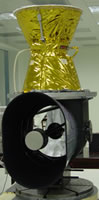
Precision Solar Sensor (Figure) is the primary instrument of the FY-2 geostationary meteorological satellite scan synchrotron control sub-system. It is used for the control of satellite synchronization and high-accuracy image alignment, and plays a key role in obtaining and formulating high quality cloud images. It was successfully launched along with the satellite in 1997, 2000 and 2004 and worked stably. Its characterizations and onboard performances are better than similar instruments made in this country and from abroad.
Remote-1 Digital Solar Sensor
Remote-1 solar sensor is the first CCD solar sensor developed in this country. Digital solar sensor was established as a phased project in August 1999, went into initial design phase in 2001 and then went into final design phase in 2003 upon the completion of the initial design. The Digital Solar Sensor was finally completed in 2004 and was successfully launched in April 2006 and went into use thereafter.
Besides, Engineering Department III also takes charge of other research projects in the aerospace and hi-tech areas. These projects have brought fame and many awards for the department, those include: one third place award of national science and technology advancement; one special award of science and technology advancement of Chinese academia of science (CAS), 3 first place CAS and shanghai municipal awards of science and technology advancement; 4 second place CAS and shanghai municipal awards of science and technology advancement; 2 third place CAS and shanghai municipal awards of science and technology advancement; Shanghai municipal model community; Shanghai municipal women model community. The department wishes to help the development of this country aerospace and remote sensing course with the hard work of generations of this department.
|